Maps reveal where severe storm could unleash flash flooding this weekend
Severe thunderstorms are forecast to sweep across large patches of the United States this weekend, with risks of flash floods in some areas, according to a new AccuWeather report.
As thunderstorms and heavy rain is forecast for parts of the Great Plains to the Mid-Atlantic coast, AccuWeather has warned that some localized areas may experience flash floods.
Flash floods are the most dangerous kind of floods that happen when rain falls faster than the ground can absorb the water. That means flooding can happen within minutes, limiting the time available to protect the public.
Densely populated areas face a higher risk of flash floods, as the increased infrastructure reduces the amount of rain absorbed by the ground. Storm drains can also become overwhelmed or plugged with debris, so roads and buildings nearby are flooded. Low spots, like underground parking garages or basements, can become deadly.
Forecasters also said that after the series of major storms this weekend, a new heat dome is expected to build across the U.S., with temperatures potentially reaching up to 115 degrees Fahrenheit in the Midwest and East.
Where Flash Floods Are Expected
According to AccuWeather, a region spanning from eastern Colorado and southeastern Wyoming through to northeastern New Mexico, as well as much of Kansas, western Kentucky and Tennessee, will be at risk of flash floods on Friday afternoon and into the night.
The area is expected to have severe thunderstorms and localized wind gusts of 60 to 70 mph, with some risk of tornadoes as well.
Parts of North Carolina, southeastern Pennsylvania and New Jersey are also set to face similar thunderstorms on Friday afternoon and evening, with wind gusts of 55 to 65 mph.

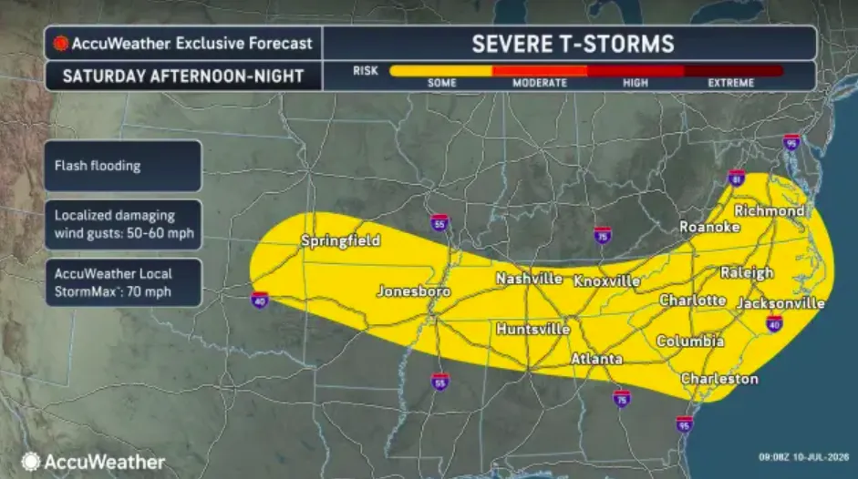
As the severe weather continues over the weekend, northeastern Georgia and much of Virginia are expected to experience thunderstorms on Saturday afternoon and night, with the potential for flash floods in some areas. Wind speeds could reach as high as 60 mph.
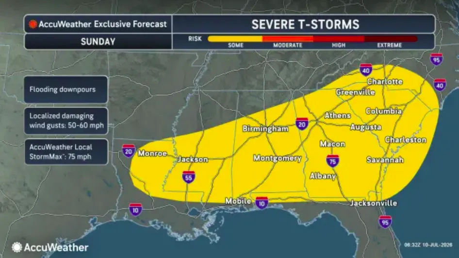
By Sunday, the severe-weather threat is forecast to travel further south, reaching from northern Louisiana through portions of Mississippi and Alabama, and east into much of Georgia and the Carolinas.
Repeated rounds of heavy downpours could significantly increase flash-flood risks, and wind gusts are expected to reach up to 60 mph.
NWS Weather Warnings This Weekend
National Weather Service has also issued flood watches and warnings for a number of states ahead of this weekend’s severe weather.
- Iowa: a flood warning is active for Shell Rock River at Shell Rock affecting Butler, Black Hawk and Bremer counties until Saturday morning.
- Wisconsin: a flood warning is active for Cedar River at Charles City affecting Floyd County until Saturday afternoon.
- Missouri: a flood warning (moderate severity) is in place for Black River near Annapolis until Sunday evening. Another flood warning is active for southwestern Saint Francois County.
- South Dakota: a flood warning is in place for Big Sioux River near Bruce affecting Brookings County until further notice and near Near Castlewood affecting Hamlin County until Friday afternoon.
- Illinois: flood warnings are in place for Illinois River at Peoria affecting Tazewell, Peoria and Woodford counties, Illinois River at Beardstown affecting Cass, Brown, Schuyler and Morgan counties and Illinois River near Havana affecting Mason, Fulton and Cass counties, until further notice.
- Kentucky: a flood warning is in place for Patoka River near Princeton until Tuesday evening.
- Colorado: a flood watch is active is in the Aspen Acres Burn Scar in Pueblo County until Friday evening.
Contact Newsweek editors on this story: Jasmine Laws and Dave Siminoff.