UN votes on major world map change: Different versions compared
A world map familiar to generations of students could lose ground under an African-led effort to represent countries and continents in their correct relative proportions.
The United Nations General Assembly is due to vote Friday on a resolution promoting the Equal Earth world map projection and other equal-area world maps that preserve countries’ relative area.
Key Points
- Togo brought the measure with backing from the African Union, which endorsed the wider #CorrectTheMap campaign in August 2025.
- Supporters argue that the Mercator projection makes Africa and other equatorial regions appear too small while enlarging northern landmasses.
- The proposal would encourage governments, schools, international organizations and technology companies to use proportionally accurate maps where scale matters.
- Mercator would not be banned under the draft resolution.
How Mercator and Equal Earth Compare
The Equal Earth projection, shown in red below, preserves the relative area of countries and continents.
The Mercator projection, shown in blue, enlarges landmasses toward the poles.
All flat world maps involve distortion, but different projections preserve different properties.
Why It Matters
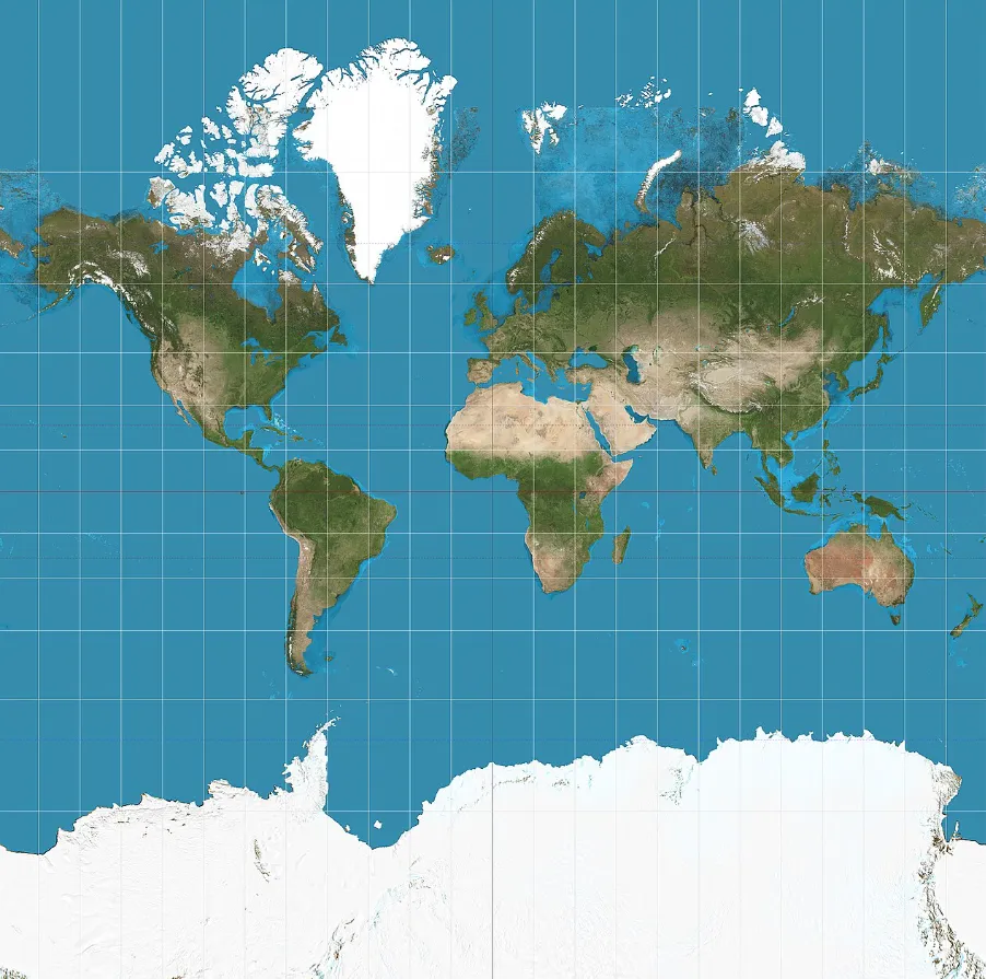
Mercator was designed for navigation, but its distortion increases toward the poles, making Europe, Russia, Greenland and North America appear larger in relation to equatorial regions.
Campaigners say that visual imbalance has particularly affected perceptions of Africa, which is 14 times larger than Greenland despite the two often appearing comparable on Mercator maps.
Why World Maps Look Different
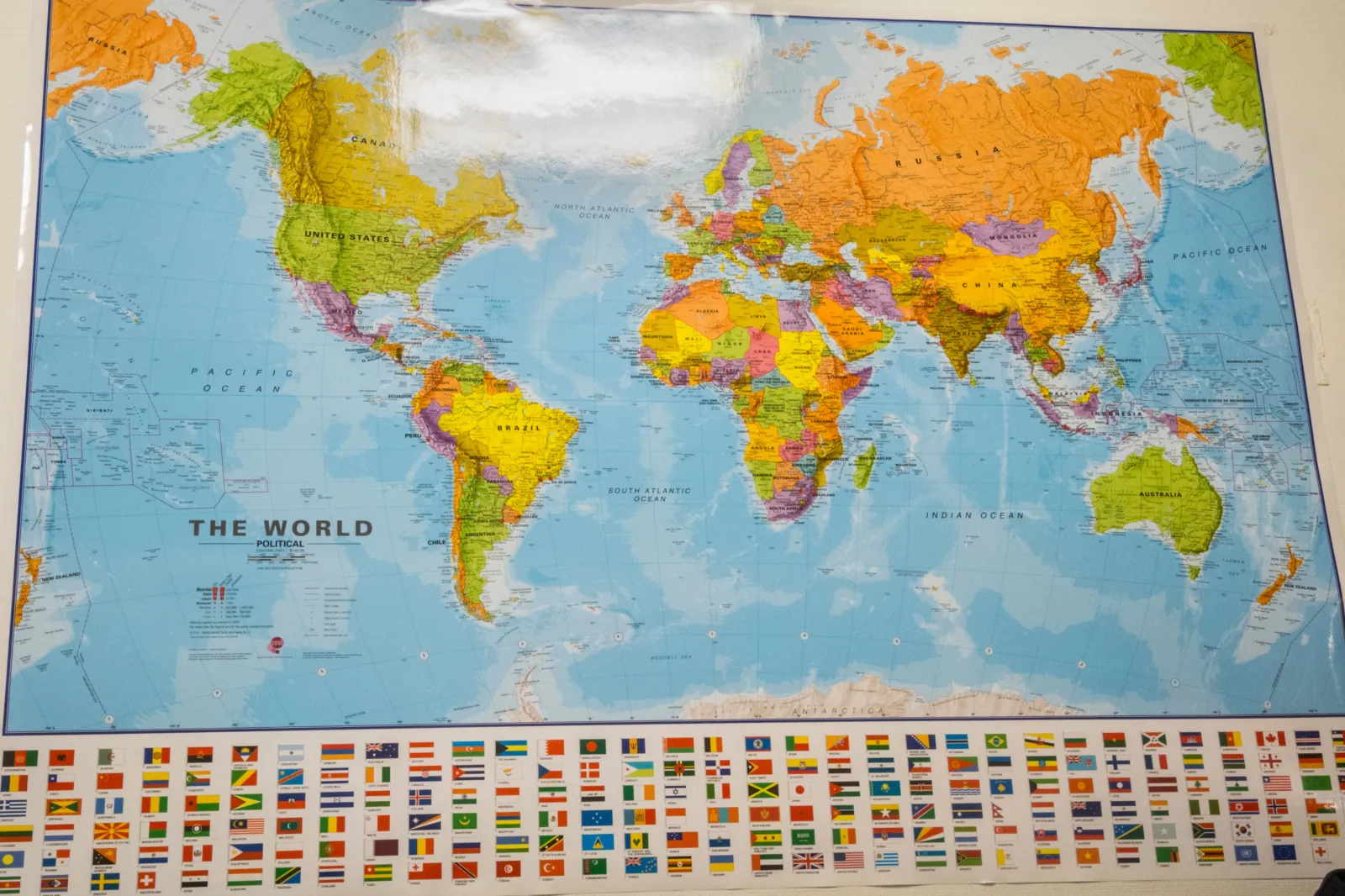
Every flat map involves a compromise because the curved surface of Earth cannot be transferred perfectly onto a rectangle.
Different projections preserve different qualities, including direction, shape, distance or area.
The Mercator projection, introduced in the 16th century, was built to help sailors navigate.
Lines of constant compass bearing appear straight, but landmasses become increasingly enlarged farther from the equator.
How Equal Earth Was Designed
Equal Earth takes another approach.
Created in 2018 by cartographers Bojan Šavrič of Esri, Tom Patterson of the U.S. National Park Service and Bernhard Jenny of Monash University, it is an equal-area projection, meaning that landmasses retain their correct size relative to one another.
Its designers sought to combine that proportional accuracy with a balanced appearance.
Equal Earth has curved outer edges intended to suggest the planet’s spherical form, while its straight parallels allow viewers to compare how far locations sit north or south of the equator.
Its overall outline resembles the widely used Robinson projection, although Robinson does not preserve relative area.
Gall-Peters also shows areas proportionally but stretches the shapes of many countries.
Equal Earth was developed as a more visually familiar alternative, with continental outlines intended to look closer to those seen on a globe.
The contrast is especially striking in Africa. On Mercator maps, the continent can appear roughly comparable to Greenland.
Equal-area designs reveal the scale gap and also make Latin America, India and other lower-latitude regions more prominent relative to northern territories.
Why Togo Is Leading the Push
Togo’s foreign minister, Robert Dussey, told an African Group briefing that the debate went beyond cartography, The Independent reported.
“A map is never neutral,” Dussey said. “It shapes perceptions, influences how the place of peoples and continents in the world is understood, and may, sometimes from the earliest years of schooling, perpetuate representations that do not correspond to geographic reality.”
“Africa is not asking for preferential treatment,” he added. “Africa is asking that its reality, aspirations and contribution to the international system be duly taken into account.”
Dussey urged African delegations to build support ahead of the vote, while Togo hosted representatives of U.N. member states on the eve of the decision.
Asked about possible opposition, he said his goal was to secure the broadest possible consensus.
The diplomatic effort builds on the #CorrectTheMap campaign, whose Change.org petition had attracted more than 11,000 signatures ahead of the vote.
Its organizers are calling on institutions including the U.N. and international media organizations to use Equal Earth in reports, data and other materials containing world maps.
Campaigners frame the issue as one of perception as well as measurement.
Correct The Map says Mercator’s treatment of the Global South affects how viewers understand Africa’s geographic, economic and political weight, describing the effort as an attempt to “change how the world views Africa.”
Newsweek contacted the Correct The Map campaign for comment via its website on Friday morning.
What Could Change Next
If the measure passes, Togo plans to hold an event in Lomé during the first quarter of 2027 with UNESCO, the African Union and technology companies including Google Maps to discuss implementation.
The vote may therefore mark the start of a longer institutional shift rather than an overnight redrawing of the world.
Contact Newsweek editors on this story: Sam Stevenson and Cristina Diciu.